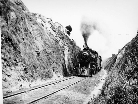
Do you know the way down San Jose (Avenue)?

Photo: Courtesy Richard Brandi, Bernal Cut Southbound 1907. S-P Trainline, official publication of the Southern Pacific Historical & Technical Society, Winter 2005. No. 82
This feels like some far-off land to me, but it’s San Francisco circa 1907.
At a recent Glen Park Neighborhood Association meeting, architectural historian and native San Franciscan Richard Brandi enlightened the group about this old train route on the south side of town. This Southern Pacific Railroad line connected San Francisco and San Jose. Part of the route went through Glen Park and the Mission District around Dolores and 28th. In the photo, this very prototypical train is zipping through the Bernal Cut: today’s San Jose Avenue.
From the neighborhood association write-up:
Brandi traced a fascinating journey along the old route, finding remnants and reminders of the tracks, with houses and other structures placed strategically and sometimes awkwardly to make way for the trains to pass.
With the rise of the auto and truck and the decline of the train, there were large lots of land vacated by the train car barns. This is where many of our present-day supermarkets are located, such as the Safeway on Mission near 30th Street.
Thanks, Beth, for sending this nifty glimpse of transit in the southeast parts of town.

I think they’re getting their supermarkets mixed up. The SF&SJ didn’t go near the current 30th St Safeway – it went two blocks to the west through Noe Valley.
But it did cross through what is now the recently closed Delanos/IGA on South Van Ness (and more importantly Rosamunde on Mission & 24th).
I believe that was the railroad shepherded into existence by Behrend Joost and his brothers, who later gave their name to Joost Ave. in Glen Park. I have one of those SF historical books (the paperback series by neighborhood) on Glen Park and it has a lot of shots of the railroad development. Pretty fascinating.
Well that’s weird, the map looks almost very similar to the current Bart route.
It’s a well-worn path. After SP built the Bayshore Cutoff (the present Caltrain route) the Bernal Cut line faded away and was terminated at the edge of the current cut. The remaining trackage ran south past Balboa Park and the old Market St. Ry./Muni Elkton Shops to Daly City, Colma, San Bruno to where the Airport now sits where the connection with the Bayshore Cutoff was made. When the I-280 Freeway was built the tracks were cut back to Elkton. (Muni had many of its streetcars delivered over that line.) When BART was designed, the old SP line was chosen as the route. The further south BART went, the less SP track there was until today when there are only BART tracks.
I think they’re getting their grocery stores mixed up — the SPRR line didn’t go near the Mission / La Lengua Safeway lot but instead 2 blocks to the west on giant berms and trestle bridges through Noe Valley.
However, the old Delano’s/IGA was built on top of the old line. And more importantly, so was Rosamunde. The land grab when they sold off the rights in the 1950s is a post in itself.
Ah, I think they’re talking about car barns. But that still wasn’t Safeway — one was across the street, and another sat between Tiffany and Mission.